

 Time is money in cultural resource management archaeology.
Sometimes, field archaeologists and GIS specialists have strained relationships within their CRM companies because field archaeos do not always know how to create maps using GIS software. We think the GIS people can just conjure a map from thin air in less than 10 seconds. And, we’re impatient when we have field crews standing around waiting for maps.
Mapping specialists don’t appreciate being treated like a robot. They can feel aggrieved about being asked to bend over backward or being stressed out over the intense workload.
The interplay between demanding archaeos and overworked GIS specialists can damage relationships and cause resentment.
Treating co-workers in a cordial manner can do much to prevent temper flair-ups. It also helps when archaeos learn how to do some quick and dirty GIS stuff so the mapping folks aren’t forced to do everything. I don’t expect field archaeologists to be creating their own maps for reports or fieldwork, but we can obtain a lot of information on our own using free programs like Google Earth and its many plugins.
When I first started in archaeology, I used to ask the mapping folks for tons of stuff. I filed requests for UTMs, APE dimensions, and township and range information. Sometimes I followed the rules and submitted a formal request. Most of the time I just barged into their office, begging and pleading that they stop what they were working on at that moment and hook me up with the info I needed.
My politeness went a long way, but, eventually, I realized the GIS folks didn’t appreciate being disturbed like 4 times a day with my random requests. Giving me the township and range info was not as simple as just clicking on a file, activating a layer, and telling me what I needed to know. I was stopping flow and taking time away from my co-workers who also needed GIS data.
It has taken me years to wean myself from asking GIS folks for everything. I’m not a pro with ArcGIS but I know a little bit and I’ve been figuring out more ways to squeeze info from Google Earth.
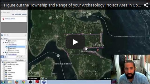
Here’s how you can figure out Township and Range information on Google Earth
If you do CRM in the American West, you know you’re going to need to know the township and range of where you’re working. It’s required on CRM report cover pages. You’ve got to list it in the introduction to your report and, most of the time, you’ve also got to explore any previous land patents in your project area.
Needless to say, T&R info plays a major role in our reports.
For the last few years I have been using a Google Earth plugin to figure out the township and range information for my projects and reports. The plugin is called PLSS in Google Earth (PLSGE) and you can download it on the Metzger+Willard Earth Survey website (http://www.metzgerwillard.us/plss/plss.html).
PLSGE is free and it’s an excellent way to figure out your township and range in Google Earth. Here’s a short YouTube video that explains how to use the plugin for cultural resource management and how this information fits into a CRM report:
Video Time Table
0:00 Introduction
0:56 MISTAKE: plugin does not have T&R information for whole country; only states surveyed by the General Land Office
1:00 Why we need to know the T&R information for cultural resource management archaeology projects
1:30 PLSS in Google Earth (PLSGE) (http://www.metzgerwillard.us/plss/plss.html)
2:15 Using PLSGE in Google Earth
2:20 Search for your project area
3:12 Open PLSGE plugin and turn on the “Township” setting
3:22 Township, Range, and Section information shown in PLSGE
4:20 Can use PLSGE on your smartphone or tablet
4:55 End
I feel like anything you can do to relieve the burden on your GIS department should be done. PLSGE is one way you can figure out the township and range of your cultural resource management archaeology project area. It works really well if you have the APE boundary as a KMZ file that can be opened in Google Earth, which would allow you to pinpoint the project area and see how it relates to the T&R grid.
I’d love to hear from you. Write a comment below or send me an email.
Check out Succinct Research’s most recent publication Blogging Archaeology. Full of amazing information about how blogging is revolutionizing archaeology publishing. For a limited time you can GRAB A COPY FOR FREE!!!! Click Here
 “Resume-Writing for Archaeologists” is now available on Amazon.com. Click Here and get detailed instructions on how you can land a job in CRM archaeology today!
 Small Archaeology Project Management is now on the Kindle Store. Over 300 copies were sold in the first month! Click Here and see what the buzz is all about.
Join the Succinct Research email list and receive additional information on the CRM and heritage conservation field.
Get killer information about the CRM archaeology industry and historic preservation.